
| What's New | Approach | Tools | Research Projects | Events | Publications | People | Contact |
| Introduction | EVIS | MURI | BIS Portal | MV | Glider | OOS | DMAC | EDSS | Feedback Planning |
The Environmental Visualization (EVIS), an ONR Future Naval Capability project is a collaborative effort among the Naval Research Laboratory, the Naval Undersea Warfare Center, and the Applied Physics Laboratory, University of Washington. The EVIS team, a multidisciplinary group of physical scientists, computer scientists, and human factors psychologists, is tailoring the weather information provided to military personnel. The team is developing a web-enabled tool that helps automate METOC thresholding and produces XML output that can be used in numerous applications. This system involves our work in cognitive psychology, human computer interaction, and software/data access schema.
Users receive satellite pictures, weather graphics, and matrices of mission effects. Mission effects are provided through the EVIS Mission Effects Services or EMES. EMES products are based on pre-set rules, which define the allowable range for particular weather parameters that impact military operations.
The participation of the EVIS team in the Horizontal Fusion (HF) program, (sponsored by the Assistant Secretary of Defense for Networks and Information Integration), resulted in an innovative capability that provides mission critical weather effect products via a service oriented architecture.
Horizontal Fusion created a cross-domain network of knowledge with net-centric access for Warfighters across the battlespace through smart pull and sharing of information. Horizontal Fusion is a direct response to operationalize, integrate, and optimize technology and operations to achieve "Power to the Edge" in the new battlespace. Personnel of the Multinational Forces-Iraq (MNF-I), the 18th Airborne Corps, are testing this new capability.
Background
The EVIS project began in 1997 as an Office of Naval (ONR) sponsored basic research project that focused on the human systems component of the U.S. Navy meteorology and oceanography (METOC) community. Researchers investigated the weather forecasting task and the associated processes such as: gathering the necessary METOC data and information from both numerical forecast models and observations; processing that information; forming a mental model of the weather; and providing an external explanation of the weather or the ocean's effect on a warfighter's mission. Based on this research an applied project was funded by the ONR Future Naval Capability program to help solve noted problems in the flow of information from the source to the end-user. In 2003, the EVIS project was selected for inclusion in the Horizontal Fusion (HF) program (HF). EVIS was tasked with developing technology to provide mission-critical environmental information to the HF network.
Web Portal
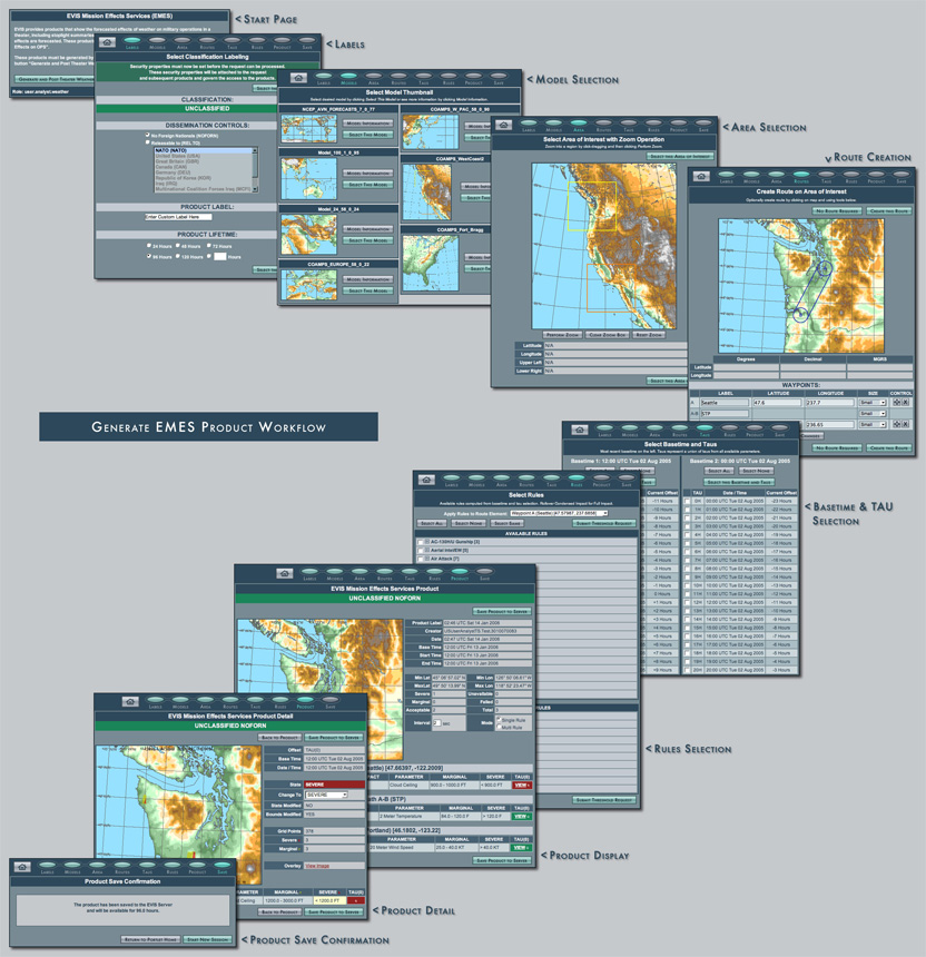
The EVIS capability developed for HF enables a user to access high-resolution METOC information from a remote server, create tailored products for mission planning, publish the specific effects, and do this faster than is possible with the currently available weather product tools. EVIS provides portal and other Java-based access mechanisms to METOC data sources through a family of value-added web services that were developed to expose and process data for METOC impacts related to specific military mission parameters. Based on a pre-set matrix of mission effect rules that can be modified by the user, the EVIS Mission Effects Services (EMES) generates mission impact summaries and related map images that are available and advertised throughout the networked enterprise.
The web portal environment allows the necessary design functionality to meet multiple users' needs, but the interface needs to communicate a workflow with information tiered in a way that aids decision making for users at different echelons. The system will include the ability for the user to create rules that combine data sources and create composite displays, or provide warnings when tactical thresholds are reached. Displays may range from the type of stoplight graphics that are used extensively in commanders' briefings to sophisticated probabilistic forecast information. Figure 2 displays a sequence of workflow snapshots from our ONR-funded and OSD-funded Horizontal Fusion EVIS weather portlet that produces web services for weather-related mission effects to operational users.
 |